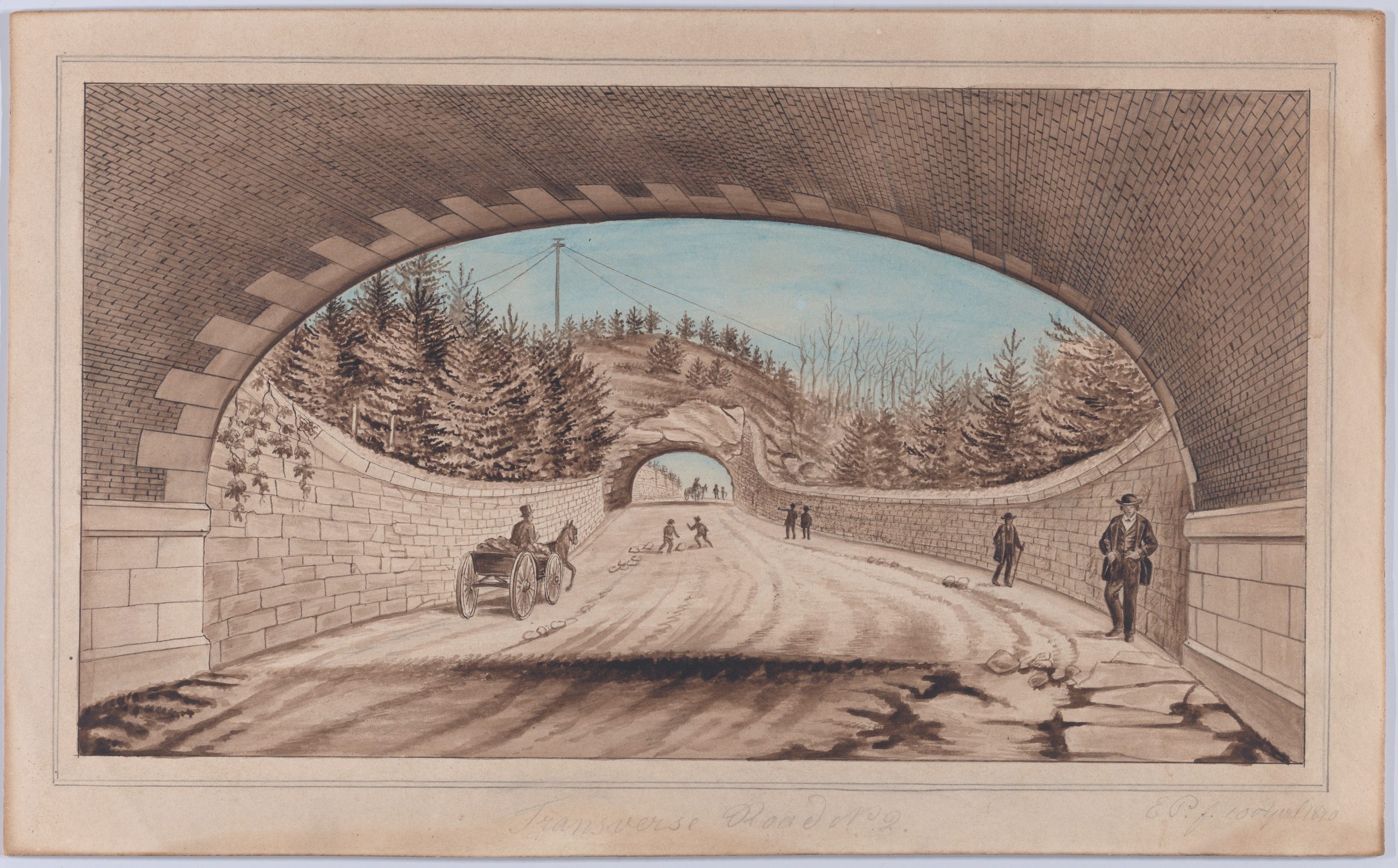
Not everything hidden in the park designed by Frederick Law Olmsted and Calvert Vaux is a road. Central Park’s history invites us to look at how a landscape is constructed—and how the decisions behind it shape public life.
Imagine four city roads that must connect Manhattan’s east and west sides, cutting across the land set aside for a park. Traffic needs to keep moving. People and goods still need to travel from one side of the city to the other. But if those roads become ordinary streets running openly through the grounds, they divide the meadows, walking routes, and views the park is supposed to provide.
This was one of the central challenges of the 1858 design competition for Central Park. Frederick Law Olmsted and Calvert Vaux did not propose getting rid of the roads. They proposed placing them at a lower grade, allowing park circulation to continue above. Bridges, retaining walls, planting, and the shaping of the land would separate different kinds of movement. A vehicle could cross the park without the visitor above having to experience that crossing as an uninterrupted city street. [1][2]
In landscape design, one of the most important decisions can be about what is visible, and from where. Here, it was not just the alignment of a road but its section that changed the experience of public space.
And Central Park’s story extends far beyond that apparently modest decision about levels. Deciding which road to conceal in a landscape is one question. Asking who had the power to determine what would happen to the land underneath it is another. Both belong to the history of the same park.
Let the city pass without dividing the park
Thirty-three proposals were submitted to the Central Park design competition in 1858. The Greensward Plan, developed jointly by Olmsted and Vaux, won. Four cross-park routes were part of the competition requirements; the two designers were not the only people to consider them. What distinguished their approach was the comprehensive solution of lowering all four required crossings and making them recede into the park landscape. [1][2]
There is a design principle here that remains useful today. Instead of relying only on signs to manage conflicting movements, we can separate them in section. City traffic can continue to function while walking paths and drives keep their own rhythm. The park remains connected to the city without subjecting visitors to the city’s pace at every turn.
The original Olmsted–Vaux report did not stop at the four required roads. It also described three additional crossings for particular kinds of carriage traffic that could be used during the day. That distinction matters. Their innovation was not to “bury every road in the park.” It was to consider where, when, and at what level different movements should meet—or avoid one another. [2]
This is also where Calvert Vaux deserves far more attention than he often receives. Central Park is frequently associated with Olmsted alone, yet the Greensward Plan was a collaboration. Vaux, who had an architectural background, supported the idea of a design competition and invited Olmsted to enter with him. His contribution to bridges and architectural features was substantial. Olmsted brought experiences ranging from agriculture to journalism, which informed how he understood land, human behavior, and urban life. Reducing the project to one man’s genius hides the collaboration that made it possible. [3][4]
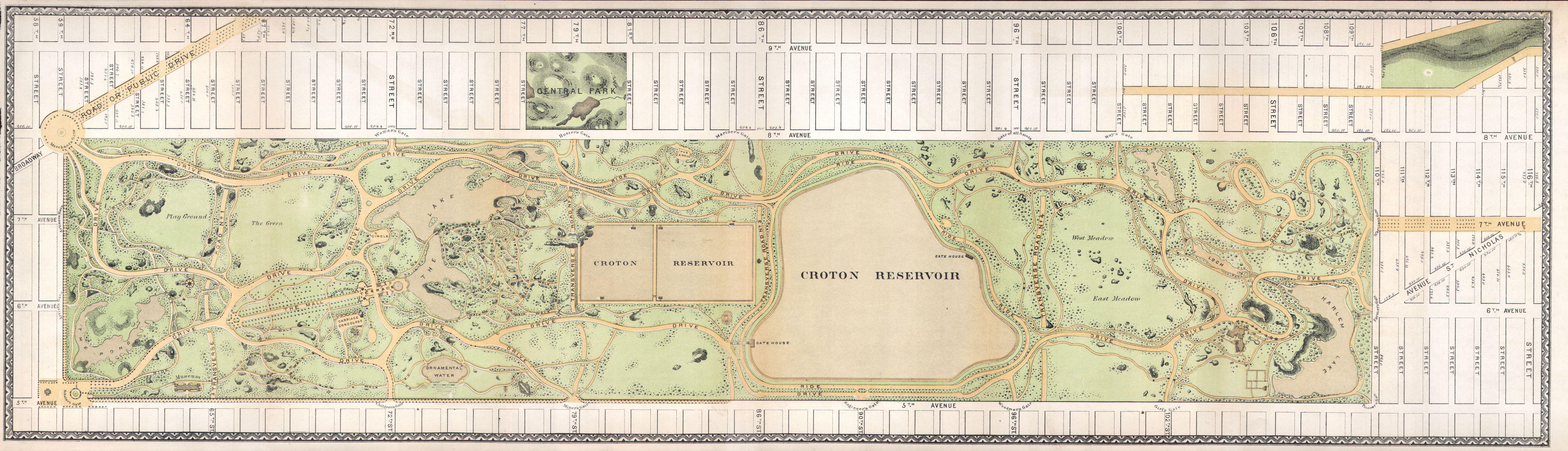

How can a landscape feel larger than it is?
Now leave the roads behind for a moment. Think about a view narrowing between groups of trees at the edge of a meadow, then opening again. Think about a rocky outcrop that holds back part of the view until you walk past it.
In Olmsted’s approach to landscape, open lawns and denser, shaded layers of planting created different experiences. In his account of Olmsted’s design principles, landscape historian Charles E. Beveridge describes the relationship between foreground and distance, the concealment of hard boundaries, and views that unfold gradually as people move through a place. A landscape’s apparent spaciousness depends not only on its physical size but also on how much of it is revealed, and in what sequence. [5]
That does not mean every curving path was deliberately drawn to make visitors lose their way. Gradients, existing terrain, circulation needs, and composition all influenced the routes. Creating a series of distinctive landscapes within Central Park’s long, narrow outline was a real design challenge. [2][5]
Nor was this simply a piece of untouched wilderness set aside for preservation. Construction involved drainage works, excavating and moving rock, and reshaping large quantities of earth. According to the Central Park Conservancy’s historical account, approximately 5 million cubic yards of stone, soil, and topsoil were moved, and some 500,000 trees, shrubs, and vines were planted. The first quantity is roughly 3.8 million cubic meters; the second refers to several kinds of vegetation, not half a million trees alone. [6]
Yet saying that everything in Central Park is artificial would be just as misleading. Some of the rock outcrops that define its character were already there. The design preserved and exposed parts of Manhattan’s existing geology while extensively reworking others. [7]
This is what interests me most as a landscape architect: a place can appear natural precisely because natural features and human intervention have been composed together. A successful landscape does not always display the work behind it. Sometimes the design allows that work to disappear from the visitor’s immediate experience. But that leads to another question: what was on this land before the transformation began?
Before this land became a park
The site of Central Park was not empty. Within what would become the park’s boundaries were homes, gardens, and established communities. One of them has a history we particularly need to understand: Seneca Village.
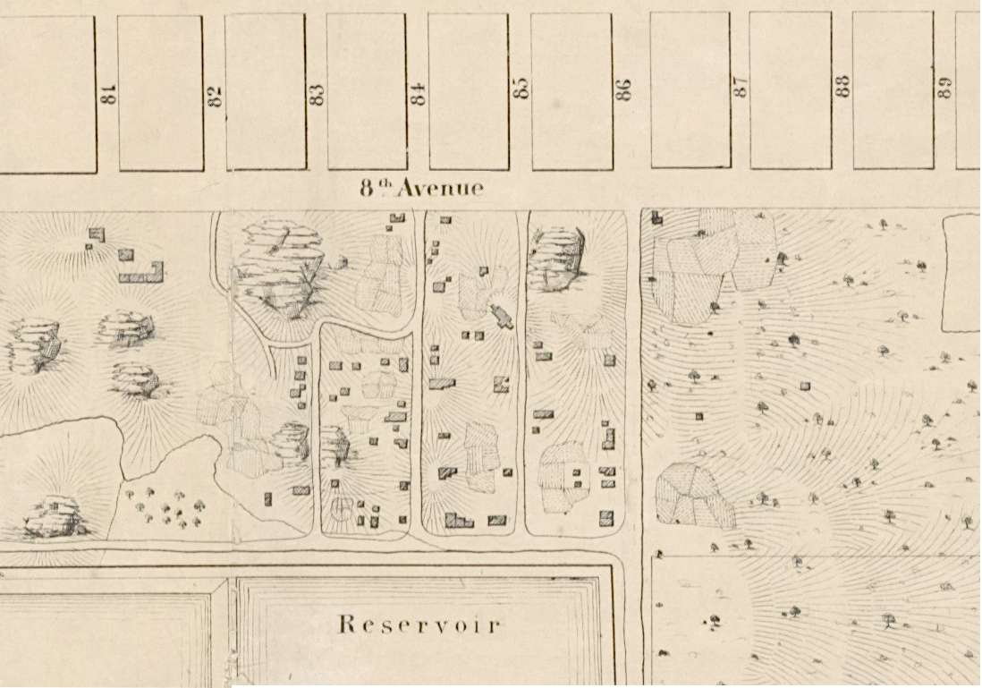
The settlement began in 1825, when free Black New Yorkers acquired property there. Over time it became home to Black families, Irish immigrants, and a smaller number of German immigrants. Historical sources estimate that about 225 people lived in Seneca Village in 1855. The community had three churches, a school, homes, and residents who owned their land. This is an estimate for Seneca Village itself—not a count of everyone living across the future park site. [8]
Ownership meant more than having a home or a plot of land. Under New York’s discriminatory voting rules of the time, property ownership was also tied to political rights for some Black men. Describing Seneca Village simply as a collection of old houses demolished for a park overlooks the social and political life that was lost. [8]
In 1853, New York State authorized the acquisition of land for the park through eminent domain. Property transfers and compensation proceedings followed, and Seneca Village residents had to leave. Some property owners received compensation; others disputed the amounts offered. But payment did not preserve the neighborhood, its religious institutions, or the community’s ability to remain together in that place. [8][9]
The chronology matters. The decision to select and acquire the land predated Olmsted and Vaux’s victory in the 1858 competition. Olmsted took up a supervisory role at Central Park in September 1857, while records indicate that final removals continued into the end of that year. It would therefore be inaccurate to portray the displacement of Seneca Village as a personal design order issued by Olmsted. It would be equally incomplete to discuss the design as if those earlier land decisions had nothing to do with its history. [3][8]
This is the most uncomfortable—and necessary—part of the story. A park intended to become a shared public good also meant the loss of homes and community for people who had lived on its site. We should be able to consider the public benefit of the landscape alongside the consequences of the decisions that made it possible.
Open gates, but whose rules?
An understated detail captures Central Park’s public ideal: the names of its entrances. In 1862, the park commissioners chose names representing occupations and social groups rather than naming the gates only for politicians or military figures: Artisans’ Gate, Merchants’ Gate, Scholars’ Gate, and Engineers’ Gate, among others. The names were physically inscribed on the gates much later. This was a decision of the park commissioners, not Olmsted acting alone. [10]
I find these names revealing because they offer a symbolic answer to the question of who belongs in the park. Craftspeople and merchants were acknowledged as part of the public the landscape represented. But did the rules allow the same breadth of participation?
Nineteenth-century park management did not imagine the grounds as a place where everyone could do whatever they pleased. Regulations from 1873 restricted activities including remaining after specified hours, playing music without permission, making fires, and selling or advertising goods. Other rules protected planting and lawns. Those restrictions should not all be treated as having the same motivation: safety, maintenance, and managing crowds were genuine concerns. Still, the rules also show institutions defining what counted as appropriate behavior in public space. [11]
There is no need to exaggerate this history. The claim that “workers were not allowed into the park on Sundays” is not an accurate summary. Olmsted’s correspondence from 1860 directly discusses heavy Sunday use. The disagreement was less about the gates being completely closed than about which activities people could pursue, and how freely they could use the park. [12]
Researcher Dorceta E. Taylor has examined this dual role in the history of American urban parks: they were promoted for health, recreation, and public benefit, while also being imagined as places where acceptable patterns of behavior could be encouraged and regulated. Explaining this entirely through Olmsted’s personality—or entirely through the interests of wealthy visitors—would overlook the roles of the other institutions and actors involved. [13]
That tension is more interesting to me than a simple accusation: a park that sought to represent everyone did not automatically offer everyone the same freedom of use. The name above a gate did not tell the whole story of the experience inside.
Is a beautiful landscape enough to make good design?
The protection and upkeep of Central Park today, despite the intensity of its use, is an achievement in its own right. Maintaining a landscape at this scale means managing much more than healthy trees: paths, water features, infrastructure, and public use all need attention.
But the historical question now takes a different form. The Central Park Conservancy explains that a substantial share of the resources supporting the park comes primarily from donations. That funding helps maintain the park to a high standard. At the same time, a New York City Council comparison of private funding for parks shows that public green spaces across the city do not all have equal access to such resources. [14][15]
I am not arguing that private donations are inherently bad, or that Central Park itself caused the inequalities surrounding it. Parks have long been discussed in relation to neighboring property values, but attributing the value of a particular building—or today’s income disparities—to one park alone would be a different and much stronger claim. A more productive question is this: how equally can people in different neighborhoods access public landscapes that are well maintained, welcoming, and safe? [16]
We can ask that question without diminishing what Central Park has achieved. As a landscape architect, I think that is precisely why we should. We look at the strength of a composition, the intelligence of a grading solution, or the effect of planting. These are genuine measures of design quality. But they do not account for the whole public value of a place.
Who can access it, which uses are permitted, whose lives changed when it was created, and how maintenance resources are distributed are questions that belong alongside the design itself.
I want to return to the four roads from the beginning of this story. Olmsted and Vaux used grades and sightlines with remarkable skill to keep essential city traffic from fragmenting the experience of the park. That remains a valuable lesson in landscape design. The rest of Central Park’s history reminds us of something else: noticing a road carefully hidden within a landscape matters—but seeing the decisions that made the landscape possible matters just as much.
Sources and further reading
- Central Park Conservancy — The Competition: 33 Plans for Central Park in 1858: https://www.centralparknyc.org/articles/plans-for-central-park
- Frederick Law Olmsted & Calvert Vaux — Description of a Plan for the Improvement of the Central Park (Greensward), 1858 text / 1868 edition: https://www.gutenberg.org/cache/epub/73830/pg73830-images.html
- Library of Congress — Central Park, Civil War, and California, 1857 to 1865: https://www.loc.gov/collections/frederick-law-olmsted-papers/articles-and-essays/timeline/central-park-civil-war-and-california-1857-to-1865/
- National Park Service — Calvert Vaux: https://www.nps.gov/people/calvert-vaux.htm
- National Park Service / Charles E. Beveridge — Olmsted Theory and Design Principles: https://www.nps.gov/frla/learn/historyculture/olmsted-theory-and-design-principles.htm
- Central Park Conservancy — Central Park History: https://www.centralparknyc.org/articles/central-park-history
- Central Park Conservancy — How Geology Influenced Central Park’s Design: https://www.centralparknyc.org/articles/geology-influenced-design
- Central Park Conservancy — Seneca Village History: https://www.centralparknyc.org/seneca-village-history
- NYC Municipal Archives — Department of Parks drawings and plans, collection guide: https://a860-collectionguides.nyc.gov/repositories/2/resources/76
- Central Park Conservancy — Portals in Time: Named Gates: https://www.centralparknyc.org/articles/portals-in-time-the-story-of-central-parks-named-gates
- The Papers of Frederick Law Olmsted — General Order for Keepers Service, March 31, 1873: https://rotunda.upress.virginia.edu/founders/default.xqy?keys=OLMS-print-02-01-02-0010&printable=yes
- The Papers of Frederick Law Olmsted — Park Board correspondence, November 1860: https://rotunda.upress.virginia.edu/founders/default.xqy?keys=OLMS-print-01-03-02-0008-0015
- Dorceta E. Taylor — Central Park as a Model for Social Control (1999): https://doi.org/10.1080/00222216.1999.11949875
- Central Park Conservancy — About the Conservancy: https://www.centralparknyc.org/ABOUT
- New York City Council — Parks in NYC / Private Funding: https://council.nyc.gov/data/parks-in-nyc/
- NYC Landmarks Preservation Commission — Central Park Historic Designation Report: https://s-media.nyc.gov/agencies/lpc/lp/0851.pdf